Chittenden County, VT climate risk
FEMA rates none of the 7 reviewed hazards as Very High in Chittenden County, VT. Modeled losses from natural hazards (expected annual loss) average about $40 million a year, for a population of 168,162. These county figures come from the FEMA National Risk Index, December 2025 release. Observation windows vary by metric and sit beside the tables below.
- Modeled expected annual loss
- $40.1 million / year
- US loss rank
- #652 of 3,232
- State loss rank
- #1 of 14
- Loss per resident
- $239 · state $344 · US $459
- FEMA overall risk rating
- Relatively Low
Vermont county modeled loss
- Positive estimates to $10.6 million
- Above $10.6 million to $11.3 million
- Above $11.3 million to $18.7 million
- Above $18.7 million to $22.2 million
- Above $22.2 million to $40.1 million
- No FEMA estimate
Chittenden County, VT ranks #1 of 14 in the state for modeled expected annual loss; the outline locates it.
View chart data
Is Chittenden County at risk of flooding?
FEMA labels riverine flooding Relatively Moderate and coastal flooding Not Applicable. Modeled annual riverine flood loss is $28,797,704; coastal flood loss is Not Applicable. These are separate hazards and county totals. A rating describes relative county risk. It does not locate water at a building or establish a flood zone. Read missing statuses using the source documentation. Keep both source labels when comparing counties. Read the county rating versus flood-zone guide before requesting a location check.
What natural hazards affect Chittenden County most?
Show tabular data
| County | Modeled expected annual loss (USD/year) | Overall risk rating |
|---|---|---|
| Chittenden County, VT | 40,136,955.03 | Relatively Low |
Show tabular data
| Hazard | Source label | Observation window |
|---|---|---|
| Coastal flooding | Not Applicable | 1996-2023 |
| Riverine flooding | Relatively Moderate | 1996-2023 |
| Hurricane | Relatively Low | 1851-2024 |
| Wildfire | Very Low | 1996-2023 |
| Earthquake | Relatively Low | 1996-2023 |
| Tornado | Relatively Low | 1950-2023 |
| Heat wave | Relatively Low | 2005-2024 |
How have heat and rain changed in Chittenden County?
Hot days
Hot days increased between the two decades.
View chart data
| Place | Days / year |
|---|---|
| 1991–2000 | 0.00 |
| 2016–2025 | 0.10 |
Warm nights
Warm nights round to 0.0 in both decades; hollow marks confirm the zero state.
View chart data
| Place | Days / year |
|---|---|
| 1991–2000 | 0.00 |
| 2016–2025 | 0.00 |
Heavy-precipitation days
Heavy-precipitation days have the same mean in both decades.
View chart data
| Place | Days / year |
|---|---|
| 1991–2000 | 0.20 |
| 2016–2025 | 0.20 |
Humid-heat days
Humid-heat days increased between the two decades.
View chart data
| Place | Days / year |
|---|---|
| 1991–2000 | 0.10 |
| 2016–2025 | 0.30 |
| Measure | 1991–2000 | 2016–2025 | Change |
|---|---|---|---|
| Hot days · ≥35°C (95°F) | 0.0 | 0.1 | +0.1 |
| Humid-heat days · heat index ≥103°F (39.4°C) | 0.1 | 0.3 | +0.2 |
| Warm nights · ≥24°C (75.2°F) | 0.0 | 0.0 | 0.0 |
| Heavy-rain days · ≥50 mm (≈2 in) | 0.2 | 0.2 | 0.0 |
| Annual maximum daily precipitation · mm | 37.9 | 38.8 | +0.9 |
Counts are days per year; a grid-cell zero does not mean the county had no such events. Thresholds, time bases and limits: county climate method.
Methodology & sensor cross-check notes
Hot-day cross-check: NOAA’s county-average daily maximum temperature gives 0.0 → 0.2 hot days a year (+0.2); NASA gives 0.0 → 0.1 (+0.1). Both series show an increase, with different counts and change sizes. The footprints differ, so agreement does not validate either count. Warm nights and precipitation were not cross-checked. Humid-heat row: Copernicus (ECMWF) reanalysis. It uses a different regional grid from the NASA measures.
No statistical significance, cause or future trend is established; this does not change the FEMA ratings above.
Climate data: NASA · Population context: US Census Bureau · Hot-day cross-check: NOAA county climate records · Humid heat: Copernicus (ECMWF). Method, sources and limitations · Climate JSON · Data credits.
{"fips":"50007","name":"Chittenden","state":"Vermont","annual":[{"year":1991,"valid_days":365,"hot_days":0,"humid_heat_days":0,"warm_nights":0,"heavy_rain_days":0,"annual_max_rain":29.44},{"year":1992,"valid_days":366,"hot_days":0,"humid_heat_days":0,"warm_nights":0,"heavy_rain_days":0,"annual_max_rain":31.26},{"year":1993,"valid_days":365,"hot_days":0,"humid_heat_days":0,"warm_nights":0,"heavy_rain_days":0,"annual_max_rain":29.63},{"year":1994,"valid_days":365,"hot_days":0,"humid_heat_days":0,"warm_nights":0,"heavy_rain_days":0,"annual_max_rain":24.12},{"year":1995,"valid_days":365,"hot_days":0,"humid_heat_days":1,"warm_nights":0,"heavy_rain_days":1,"annual_max_rain":53.05},{"year":1996,"valid_days":366,"hot_days":0,"humid_heat_days":0,"warm_nights":0,"heavy_rain_days":0,"annual_max_rain":39.3},{"year":1997,"valid_days":365,"hot_days":0,"humid_heat_days":0,"warm_nights":0,"heavy_rain_days":0,"annual_max_rain":35.14},{"year":1998,"valid_days":365,"hot_days":0,"humid_heat_days":0,"warm_nights":0,"heavy_rain_days":0,"annual_max_rain":45.01},{"year":1999,"valid_days":365,"hot_days":0,"humid_heat_days":0,"warm_nights":0,"heavy_rain_days":1,"annual_max_rain":56.49},{"year":2000,"valid_days":366,"hot_days":0,"humid_heat_days":0,"warm_nights":0,"heavy_rain_days":0,"annual_max_rain":35.18},{"year":2001,"valid_days":365,"hot_days":0,"humid_heat_days":null,"warm_nights":0,"heavy_rain_days":0,"annual_max_rain":32.18},{"year":2002,"valid_days":365,"hot_days":0,"humid_heat_days":null,"warm_nights":0,"heavy_rain_days":0,"annual_max_rain":47.34},{"year":2003,"valid_days":365,"hot_days":0,"humid_heat_days":null,"warm_nights":0,"heavy_rain_days":0,"annual_max_rain":37.98},{"year":2004,"valid_days":366,"hot_days":0,"humid_heat_days":null,"warm_nights":0,"heavy_rain_days":0,"annual_max_rain":30.39},{"year":2005,"valid_days":365,"hot_days":0,"humid_heat_days":null,"warm_nights":0,"heavy_rain_days":1,"annual_max_rain":56.27},{"year":2006,"valid_days":365,"hot_days":0,"humid_heat_days":null,"warm_nights":0,"heavy_rain_days":0,"annual_max_rain":45.4},{"year":2007,"valid_days":365,"hot_days":0,"humid_heat_days":null,"warm_nights":0,"heavy_rain_days":0,"annual_max_rain":35.65},{"year":2008,"valid_days":366,"hot_days":0,"humid_heat_days":null,"warm_nights":0,"heavy_rain_days":0,"annual_max_rain":34.94},{"year":2009,"valid_days":365,"hot_days":0,"humid_heat_days":null,"warm_nights":0,"heavy_rain_days":0,"annual_max_rain":32.16},{"year":2010,"valid_days":365,"hot_days":1,"humid_heat_days":null,"warm_nights":0,"heavy_rain_days":1,"annual_max_rain":52.5},{"year":2011,"valid_days":365,"hot_days":0,"humid_heat_days":null,"warm_nights":0,"heavy_rain_days":1,"annual_max_rain":87.7},{"year":2012,"valid_days":366,"hot_days":0,"humid_heat_days":null,"warm_nights":0,"heavy_rain_days":0,"annual_max_rain":32.71},{"year":2013,"valid_days":365,"hot_days":0,"humid_heat_days":null,"warm_nights":0,"heavy_rain_days":0,"annual_max_rain":39.94},{"year":2014,"valid_days":365,"hot_days":0,"humid_heat_days":null,"warm_nights":0,"heavy_rain_days":0,"annual_max_rain":29.38},{"year":2015,"valid_days":365,"hot_days":0,"humid_heat_days":null,"warm_nights":0,"heavy_rain_days":0,"annual_max_rain":32.22},{"year":2016,"valid_days":366,"hot_days":0,"humid_heat_days":0,"warm_nights":0,"heavy_rain_days":0,"annual_max_rain":35.7},{"year":2017,"valid_days":365,"hot_days":0,"humid_heat_days":0,"warm_nights":0,"heavy_rain_days":0,"annual_max_rain":34.71},{"year":2018,"valid_days":365,"hot_days":1,"humid_heat_days":1,"warm_nights":0,"heavy_rain_days":0,"annual_max_rain":31.13},{"year":2019,"valid_days":365,"hot_days":0,"humid_heat_days":0,"warm_nights":0,"heavy_rain_days":0,"annual_max_rain":33.31},{"year":2020,"valid_days":366,"hot_days":0,"humid_heat_days":0,"warm_nights":0,"heavy_rain_days":0,"annual_max_rain":45.92},{"year":2021,"valid_days":365,"hot_days":0,"humid_heat_days":0,"warm_nights":0,"heavy_rain_days":0,"annual_max_rain":29.17},{"year":2022,"valid_days":365,"hot_days":0,"humid_heat_days":0,"warm_nights":0,"heavy_rain_days":0,"annual_max_rain":32.16},{"year":2023,"valid_days":365,"hot_days":0,"humid_heat_days":0,"warm_nights":0,"heavy_rain_days":2,"annual_max_rain":63.4},{"year":2024,"valid_days":366,"hot_days":0,"humid_heat_days":0,"warm_nights":0,"heavy_rain_days":0,"annual_max_rain":48.66},{"year":2025,"valid_days":365,"hot_days":0,"humid_heat_days":2,"warm_nights":0,"heavy_rain_days":0,"annual_max_rain":33.44}],"metrics":{"hot_days":{"baseline":0,"recent":0.1,"delta":0.1},"humid_heat_days":{"baseline":0.1,"recent":0.3,"delta":0.2},"warm_nights":{"baseline":0,"recent":0,"delta":0},"heavy_rain_days":{"baseline":0.2,"recent":0.2,"delta":0},"annual_max_rain":{"baseline":37.862,"recent":38.76,"delta":0.898}},"crosscheck":{"metric":"hot_days","annual":[{"year":1991,"hot_days":0},{"year":1992,"hot_days":0},{"year":1993,"hot_days":0},{"year":1994,"hot_days":0},{"year":1995,"hot_days":0},{"year":1996,"hot_days":0},{"year":1997,"hot_days":0},{"year":1998,"hot_days":0},{"year":1999,"hot_days":0},{"year":2000,"hot_days":0},{"year":2016,"hot_days":0},{"year":2017,"hot_days":0},{"year":2018,"hot_days":0},{"year":2019,"hot_days":0},{"year":2020,"hot_days":0},{"year":2021,"hot_days":0},{"year":2022,"hot_days":0},{"year":2023,"hot_days":0},{"year":2024,"hot_days":0},{"year":2025,"hot_days":2}],"baseline":0,"recent":0.2,"delta":0.2,"agreement":"same direction"}}How does El Niño affect Chittenden County winters?
Strong El Niño winter precipitation
6 of 9 strong El Niño winters were wetter than normal. The vertical line marks 100% of normal precipitation.
View chart data
| Winter | Precipitation (% of normal) |
|---|---|
| 1957–58 | 138.068 |
| 1965–66 | 80.132 |
| 1972–73 | 108.694 |
| 1982–83 | 88.895 |
| 1991–92 | 88.973 |
| 1997–98 | 130.769 |
| 2009–10 | 107.570 |
| 2015–16 | 122.206 |
| 2023–24 | 114.722 |
NOAA and IRI both give 100% odds that El Niño conditions (tropical Pacific ONI of at least 0.5°C, not a local weather forecast) are present this winter. In Chittenden County, 6 of 9 past strong El Niño winters were wetter than normal; the median winter had 109% of normal precipitation (rain and melted snow). The driest, 1965–66, had 80%.
| Winter | ONI | Precipitation | Temp. | Heavy days | Claims |
|---|---|---|---|---|---|
| 1957–58 | 1.7 | 138% | +2.2°F | 0 | — |
| 1965–66 | 1.6 | 80% | +1.7°F | 1 | — |
| 1972–73 | 1.8 | 109% | +0.3°F | 0 | — |
| 1982–83 | 2.1 | 89% | +3.6°F | 1 | 0 |
| 1991–92 | 1.5 | 89% | −1.5°F | 0 | 0 |
| 1997–98 | 2.4 | 131% | +3.3°F | 2 | 1 (#4) |
| 2009–10 | 1.5 | 108% | +1.1°F | 2 | 0 |
| 2015–16 | 2.6 | 122% | +5.7°F | 1 | 0 |
| 2023–24 | 2.0 | 115% | +5.8°F | 2 | 7 (#2) |
Winter normals and temperature baseline
Chittenden County normals, 1990–91 to 2019–20 winters: 8.1 inches of precipitation (rain and melted snow) and 0.7 heavy days. Temperature is set against the county’s own winter trend of +0.7°F per decade since 1951–52.
Flood claims: December–February, from 1978 (— = before the data). The rank compares each winter with all 47 winters from 1978–79 to 2024–25 (#1 is the most claims; no rank is shown for 0 claims). The median winter had 0 claims; 2 of 6 strong winters in the data were above it. Insured exposure grew over time, so counts are not comparable across decades.
Past tendency is not a forecast and not a property-level finding. Before winter: four checks for property teams.
Sources: NOAA county climate records and Pacific climate assessments; FEMA National Flood Insurance Program claims. Method and limits · El Niño 2026–27.
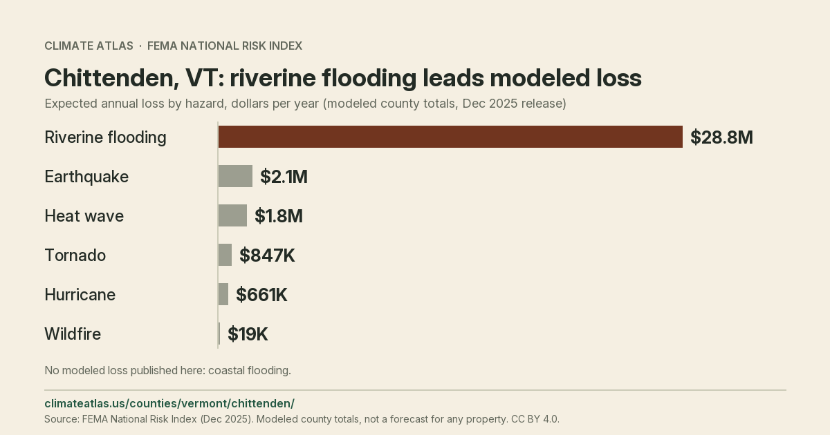
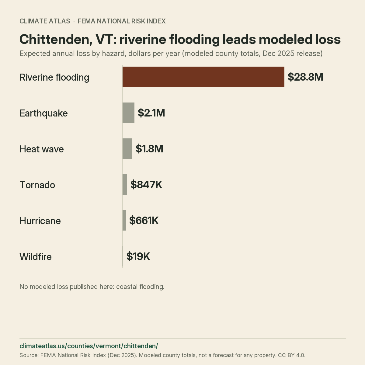
What are the modeled losses by hazard?
From 1991–2000 to 2016–2025, hot days near Chittenden County changed from 0.0 to 0.1 per year. Heavy-rain days changed from 0.2 to 0.2. The table retains humid heat, warm nights and maximum daily rain. Compare the periods alongside the source notes. These decade means describe past conditions; they do not predict a future year or establish a trend.
Chittenden County’s modeled loss across all hazards is $40,136,955 per year. The FEMA National Risk Index ranks the hazards below by modeled loss, not rating category.
Show tabular data
| Hazard | Total loss ($/yr) | Of which buildings ($/yr) | Observation window |
|---|---|---|---|
| All hazards (composite) | $40,136,955 | $32,558,646 | 1996-2023 |
| Riverine flooding | $28,797,704 | $28,508,887 | 1996-2023 |
| Earthquake | $2,147,955 | $1,833,011 | 1996-2023 |
| Heat wave | $1,797,421 | Not published | 2005-2024 |
| Tornado | $846,921 | $232,690 | 1950-2023 |
| Hurricane | $661,061 | $606,338 | 1851-2024 |
| Wildfire | $18,585 | $16,249 | 1996-2023 |
| Coastal flooding | Not available | Not available | 1996-2023 |
These modeled county totals do not estimate property losses, insurance inputs or forecasts. Do not multiply them by location counts.
Reuse this chart
What is exposed in Chittenden County?
Population and asset values show the scale behind county losses. These county totals are exposure measures, not loss figures.
Show tabular data
| Measure | Value | Observation window |
|---|---|---|
| Resident population | 168,162 | 2020-2020 |
| Building replacement value | $40,414,880,347 | 2020-2020 |
| Agricultural market value | $56,100,811 | 2022-2022 |
What do vulnerability and resilience show?
These relative rankings describe susceptibility to hazard impacts and capacity to recover. They measure no individual asset or outcome.
Show tabular data
| Measure | Score | Observation window |
|---|---|---|
| Social vulnerability index | 10.6 | 2020-2020 |
| Community resilience index | 94.3 | 2020-2020 |
Chittenden County in the state and national rankings
National placement for Chittenden County is #652 of 3,232, with an expected annual loss estimate of about $40.1 million. The county ranks #1 of 14 in Vermont and accounts for 18.1% of state loss. This $40.1 million estimate is a long-run modeled annual average, not a forecast for a particular year. Lancaster County, SC ranks immediately above it, with about $40.1 million in modeled annual loss. The next lower national total is about $40.1 million, in Alexandria City, VA. The nearest lower state total is about $25.1 million, recorded for Windsor County, VT. The dollar gap is about $15.0 million; that county accounts for 11.4% of statewide modeled loss.
County hazard loss mix
Riverine Flood leads the modeled expected annual loss mix; bar lengths share a zero baseline.
View chart data
| Hazard | USD / year | Share |
|---|---|---|
| Riverine Flood | 28,797,704.46 | 71.7% |
| Earthquake | 2,147,954.67 | 5.4% |
| Heat Wave | 1,797,420.60 | 4.5% |
| Cold Wave | 1,587,262.00 | 4.0% |
| Lightning | 1,417,905.70 | 3.5% |
| Strong Wind | 1,222,774.93 | 3.0% |
| Other | 3,165,932.69 | 7.9% |
National hazard loss ranks
Riverine Flood ranks #419 of 3,232 by modeled expected annual loss. Higher percentiles mean larger modeled losses.
View chart data
| Hazard | Rank | Percentile |
|---|---|---|
| Riverine Flood | #419 of 3,232 US · #1 of 14 in VT | 87.07 |
| Earthquake | #611 of 3,232 US · #1 of 14 in VT | 81.13 |
| Heat Wave | #495 of 3,202 US · #1 of 14 in VT | 84.57 |
| Cold Wave | #1,109 of 3,232 US · #3 of 14 in VT | 65.72 |
| Lightning | #248 of 3,222 US · #1 of 14 in VT | 92.33 |
| Strong Wind | #683 of 3,225 US · #1 of 14 in VT | 78.85 |
Modeled loss per resident
Chittenden has about $239 in modeled expected annual loss per resident. State and US values divide total loss by total population.
View chart data
| Place | USD / resident / year |
|---|---|
| Chittenden | 238.68 |
| Vermont | 344.23 |
| US | 459.35 |
Chittenden County hazard estimates
Riverine Flood
FEMA models about $28.8 million in expected annual loss from riverine flooding, placing the county #419 of 3,232 nationally. At 71.7% of the county’s modeled loss, the hazard places #1 of 14 statewide; FEMA assigns a Relatively Moderate rating; the same rating for riverine flooding covers 2 Vermont counties and 639 across the US.
Earthquake
The national loss rank for earthquakes is #611 of 3,232, based on about $2.1 million in modeled expected annual loss. In Vermont, this estimate ranks #1 of 14 and represents 5.4% of the county’s modeled loss; FEMA assigns a Relatively Low rating; the same rating for earthquakes covers 2 Vermont counties and 962 across the US.
Heat Wave
FEMA models about $1.8 million in expected annual loss from heat waves, placing the county #495 of 3,202 nationally. This hazard makes up 4.5% of the total; FEMA assigns a Relatively Low rating, and its loss ranks #1 of 14 in Vermont; for heat waves, 5 state counties and 1,246 US counties share that label.
Cold Wave
With about $1.6 million in modeled expected annual loss from cold waves, the county ranks #1,109 of 3,232 in the national comparison. Its 4.0% share of total loss comes with a state loss rank of #3 of 14; FEMA assigns a Relatively Low rating; the Relatively Low label covers 11 state counties and 1,307 nationally for cold waves.
Lightning
The national loss rank for lightning is #248 of 3,222, based on about $1.4 million in modeled expected annual loss. At 3.5% of the county’s modeled loss, the hazard places #1 of 14 statewide; FEMA assigns a Relatively High rating, matching 461 US counties, including 1 in Vermont, for this hazard.
Strong Wind
With about $1.2 million in modeled expected annual loss from strong wind, the county ranks #683 of 3,225 in the national comparison. At 3.0% of the county’s modeled loss, the hazard places #1 of 14 statewide; FEMA assigns a Relatively Moderate rating, matching 1,011 US counties, including 2 in Vermont, for this hazard.
Between riverine flooding and earthquakes, the modeled dollar gap is about $26.6 million; their shares differ by 66.4 percentage points. The loss estimate for earthquakes exceeds heat waves by about $351,000, equivalent to 0.9 percentage points of total loss. About $210,000 separates heat waves from cold waves in the local estimates, equivalent to 0.5 percentage points of county loss. The loss estimate for cold waves exceeds lightning by about $169,000, equivalent to 0.4 percentage points of total loss. The loss estimate for lightning exceeds strong wind by about $195,000, equivalent to 0.5 percentage points of total loss.
Population and recorded values
Chittenden County covers about 626 square miles, with 168,162 residents in FEMA data. For building value, the source records about $40.41 billion. The recorded agricultural value is about $56.1 million. Total modeled loss averages about $239 per resident annually, compared with about $344 statewide. The county holds 26.2% of the state population, compared with 18.1% of modeled loss. Buildings account for 23.2% of recorded Vermont building value. The county holds density position 1 of 14 in Vermont, using FEMA’s recorded population and area. The population-to-area ratio is about 269 residents per square mile; statewide it is about 66. At 168,162 residents, the county compares with the Vermont county median of about 37,330. Of FEMA’s US population, 0.1% lives here, alongside 0.0% of national modeled annual loss. The county’s about $239 per resident compares with about $459 nationally in modeled annual loss. About $37.0 million of annual loss falls within the six leading hazards, accounting for 92.1% of the total. Other hazards account for the remaining 7.9% of modeled loss, about $3.2 million. The county’s number 7 hazard by dollar loss is tornadoes: about $847,000, with a state rank of #2 of 14. Its national loss rank is #1,824 of 3,225, and it represents 2.1% of the county’s modeled loss. The county’s number 8 hazard by dollar loss is hurricanes: about $661,000, with a state rank of #6 of 14. With 1.6% of county loss, this hazard has national placement #735 of 2,485.
FEMA labels and risk score
Chittenden County has a FEMA risk index score of about 63.9, ranking #1,136 of 3,144 nationally. FEMA labels risk index as Relatively Low, matching 6 county records across Vermont. For expected annual loss, FEMA assigns Relatively Low; 6 counties in Vermont have that label. The social vulnerability rating is Very Low, a label shared by 8 of 14 Vermont counties. The community resilience rating is Very High, a label shared by 6 of 14 Vermont counties. Within Vermont, the risk score places #1 of 14 and the dollar loss places #1 of 14. Within Vermont, 6 counties share both labels: Very Low vulnerability and Very High resilience. This county accounts for 39.6% of that group’s annual loss, while the group accounts for 45.8% across Vermont. On the state risk-score list, Windsor County, VT sits immediately below, scoring about 61.6 and ranking #2 of 14. For that neighboring score, the risk index category is Relatively Low, and the county’s state loss share is 11.4%. Nationally, 625 counties carry the same Very Low social vulnerability label, covering 23.7% of FEMA’s recorded population. FEMA lists 629 county records with Very High community resilience; together they contain 27.2% of its US population total. Across the county’s hazard ratings, 1 carry Relatively High: lightning. FEMA assigns Relatively Moderate to 5 hazards here, covering avalanches, ice storms, riverine flooding, strong wind, winter weather. The county’s Relatively Low group contains 6 hazards: cold waves, earthquakes, heat waves, hurricanes, landslides, tornadoes. Across the county’s hazard ratings, 2 carry Very Low: hail, wildfires.
What else should I know about Chittenden County?
What does FEMA estimate for cold waves in Chittenden County?
Chittenden County has about $1.6 million in modeled expected annual loss from cold waves, with a Relatively Low rating.
What is the FEMA social vulnerability rating for Chittenden County?
FEMA assigns Chittenden County a Very Low social vulnerability rating.
Where does Chittenden County rank nationally by loss?
Chittenden County places #652 of 3,232 for modeled expected annual loss.
What is the FEMA risk index rating for Chittenden County?
FEMA assigns Chittenden County a Relatively Low risk index rating.
Where does Chittenden County rank within Vermont?
Chittenden County ranks #1 of 14 for modeled expected annual loss.
What does FEMA estimate for riverine flooding in Chittenden County?
For riverine flooding, FEMA lists Chittenden County at Relatively Moderate, with about $28.8 million in modeled expected annual loss.
What does FEMA estimate for earthquakes in Chittenden County?
For earthquakes, FEMA lists Chittenden County at Relatively Low, with about $2.1 million in modeled expected annual loss.
Where next for Chittenden County?
See how the county compares across the state in Vermont natural hazard risk by county, download the FEMA county hazard data, or review the county climate risk data API and bulk files. Check the sources and what each measure can show on the methodology page.